American Sabbatical 050: 11/9/96
Mojave
11/9.. Providence Mountain.
Kingman is another young town, full of pastel pickups with jumbo tires. I’d thought that rustbowl
flight and pensioneering had filled the southwest with aging snowbirds,
but the geriatrics are either hiding behind their swamp-coolers
(old-style desert air conditioning which blows air through watersoaked
matting .. when it gets into the 90s it feels like.. well, a swamp),
or they've all gone to Vegas to get lucky. Does everyone seem
younger when you’re over the hill? UhOh.
|

Desert Vista
|
Kingman’s bungalows now sprawl across the valley floor to westward,
until raw houselots climb up the Black foothills. We cruised along
the long rising fourlane, doing a soul-easy 45mph in the morning
mildness. When the narrowed roadway wiggled into sintered mountains
we were astonished again by the wild variety of the desert. I’d
expected DESERT to be barren expanses of sameness. I now realized
there's as much diversity in aridity as there is in artistic taste.
Every rise and bend reveals new rockscapes. Backgrounds of orange,
beige, bronze, umber, sienna.. fading into purple distances. Slumped
mudstone outcrops, eon-carved limestone millinery, sensuous erosions,
fractured intrusions, scattered boulders covering hundreds of
acres, eloquent solitaries.
Profusely
|
But the big surprise is the profusion of plant life. Every terrain
has its mix of desiccated survivors, and the more you look, the
more there are. Each species has its peculiar tinge and texture.
Wide-angle views shift from clumps of dusty aqua to sprays of
sour green to a fuzz of rusty bronze to puffs of wheat-straw to
gray filigree and beyond. All the permutations dance discretely
against the stonescape, every plant standing apart to conserve
its private moisture, so the big picture is a dot-matrix of sunsucked
flora. And this is in the middle of November. What must it be
like after a spring rain? |
Not sure I’d want to drive across this country during a rain.
All those "DIP"s are drywashes, and to judge by the embankments,
a freshet is serious business here. Where the railroad crosses
these dips the bridgework is impressive. Maybe I’ll take the train
in April.
Our road took us through Bullhead City, and over the Colorado
at the Davis Dam, another bone in the lady’s throat. And another
casino empire is rising on the Nevada side, where the power is
cheap: Laughlin. A brand spanking shiny city, with a six-story
casino, built to look like a riverboat moored to the shore, highrise
hotels with golden glass, and big signs enough to deny the night.
Vegas may be reaching out to the family vacationers, but it still
has a sleazy underside. Laughlin is scrubbed and polished enough
to make your maiden aunt feel comfortable.. about dropping her
loose change. We got sidetracked in Laughlin and drove round the
whole blinking burg before we found our way out. Clever road design,
I say.
| The road to Needles runs along the Colorado valley here, and willow
thickets vie for domination with shorefront development. Laughlin
is tentacling out with riverside haciendas, just as Las Vegas
is spawning Pahrumps and Laughlins. Desert development mimics
the plantlife. It thickens and bushes up along the watercourses,
but out on the thirsty flats the houses sit wide apart in their
catchments, solitary, but with neighbors in view. Or the houses
cluster together inside a walled compound, a community of isolates
sharing services under a canopy of tile roofs, just as the desert
plants sometimes cluster in communities: grasses in the shrubshade.
The desert waits beyond the sprinkleplots of green, in thorny
silence. |

Thirsty Landscape
|
We struck on the major artery at Needles and woofed into a slot
between semis. No dawdling along in the scenery on Rt. 40. We
rode the jetstream for 15 miles, and blew back out into the cacti
on old route 66. It winds from Chicago to LA. But it’s closed
west of Essex. And Essex is closed, period. We’d hoped to get
bread and cheese there, but all that’s on the go in this bypassed
highway town is the dust, moving through. So we turned north into
the Mojave, hunting a desert solitude.
The byroad was empty enough to collect your thoughts, and a wonderland
of spiky, thorny, hooked, and barbed presences surrounded us,
whispering: "Keep to yourself." The eyesmarting sun was pinking
our flesh, and fine astringent aromas tingled our nostrils. We
were hoping for a campsite with some desert trails, and Seth’s
Free Camping Guide said they could be had thisaway. But without
a proper map we we stymied at the junctions and waved our hands
in the air. "Mitchell Caverns, camping,”"a sign said. "Why not?"
we said.

Prickly
|
The roads fanning into the Mojave seem to disappear into deadend
mountains or fade into dirt traces in the heat-hazed distance.
Our road spiraled up onto the shoulder of Providence Mountain
and terminated at the ranger station, with its solar satellite
telephone, sparkling toilets, rustic log info center with a shady
porch, and a clutch of shiny white California State Broncos. A
pair of ravens croaked at our arrival. |
Turns out there’s a cavern tour just forming up to head in, and
the idea of a cool cave tempts Peggy out of her claustrophobia.
We join the line. Ramon, our tour leader, is exhaustingly longwinded,
and we are a captive audience. Literally. After leading us along
the cliff face for half a mile, we clamber up into one of two
“eyes of the mountain”, 8-foot diameter portals, and Ramon locks
the vandal gate behind us. We can’t escape without his keys.
His loquaciousness serves a subtle end, however. All the drone
about stalactites, stalagmites, straws, cave shields, draperies,
flow stone, bell canopies, dripstone, coral pipes, and whatall
keeps us frozen in place, staring into the intricacies of the
limestone excrescence. The warm (as it haps) interiority of dusty
old earthmagic echoed with reminiscence of cathedral cloisters
in summer. We are awkwardly crammed together, 30 strangers in
the heart of Providence, and all we can do is let go of the discomfort,
and open our eyes in the gloom. Our guide intimated he had been
transformed from a barrio boy to a different sort of native by
coming into the earth here some 3000 times, and it had been a
ritual center for local shamans long before it became a roadside
attraction. It certainly turned our desert day inside-out.
| When we resurfaced, the sun was over the mountain, and the campsites
in shadow. This November camping doesn’t offer much evening entertainment.
Even in Southern California the sun sets around 5:30. No problem
getting enough sleep. I wandered off in the gloaming, downhill
from a crest trail, to sit and commune with the dryness. The ravens
rooked at me. Small birds made nervous noises in the big yuccas.
In the fading light I encountered a withered vine spread-eagled
on the mountainside, its dusty white-aqua leaves trailing across
the dark among looming cactus and rabbit bush. Its one radiant
yellow gourd, about the size of a baseball, glowed like a moon
fell down. It was featherlight and dry to the touch. I left it
clinging to the vine, and watched the stars come out. |

On Providence Mountain
|
We haven’t done much stargazing this journey, what with all the
cold and rain, but on this mild mountainside, looking south, we
might enjoy a full show. We sat on a picnic table, arms around
each other, to watch the first act. It wasn’t quite what we expected.
As the day sounds died, the visitors’ cars buzzed downslope, and
the rangers shut up shop, the sound of the station’s big generator
cranked into consciousness. A continuous RRRRRRRRRRR. Misty whiteness
flowed from west to east, between us and the Clipper Mountains..
a wall of stone to the distant south.. bleaching their bases until
darkness blotted all the colors out. Then out across the Mojave,
20 miles away, a thin strand of red and white lights streamed
and twinkled across the darkness. The lifeblood of a continent
flowing endlessly along Route 40. Appearing from and disappearing
behind the Granite Mountains to the southwest and over the pass
in the Piutes to the southeast. The moving finger of our time,
making a line in the sand. Highflying jets inbound to LAX, would
momentarily block the generator hum with noise of their passage,
but the highway roar was only in the eye. Like standing way back
and watching yourself race by.

Yucca perspective
|
As the familiar planetarium projection rolled up, raising the
Pleiades over the Piutes, a skyglow illuminated the horizon beyond
the New York Mountains to the northeast, like a forerunner of
the moon rising into clouds.. but wait.. the moon isn’t full.
Or that far north. Las Vegas is, though.. and only 60 miles away.
Obviously a high thin cloudcover had slid overhead, reflecting
the lights of Lady Luck. Yes, there to the east northeast a lesser
glow marked the casinos of Laughlin. Pie in the sky.
|
We laughed at our innocence. Trying to get away to the desert!
And then the UFOs came. Emanating from a spot in the blackness
below the Clippers, a pulsing display of colored lights rose up
to the zenith and covered an arc of 60 degrees east to west. Maybe
20 lights winking on and off in an indecipherable pattern. There
seemed to be a big array of winking lights on the ground out there.
Could THEY be making a laser lightshow in clear air? Or high haze?
Or what? Then the aerial lights fanned toward the west and twinkled
off behind the Granite mountains. The hair on our necks wiggled.
The we remembered the signs to the Marine Corps Weapons Testing
Facility over that way. Starwar maneuvers? Or just night copter
missions? So much for Desert Solitude. We giggled into our tent.
It was all of 7:30.
(Memo #43)
Nov. 9 - MITCHELL CAVERNS, MOJAVE DESERT
Who? state tour guides
What? caverns with extremely rare formations (cave shield, coral
pipes, soda straws)
Where? Mojave Desert 60 miles southwest of Las Vegas
When? formation over eons
How? mainly dripping of fluid through limestone fissures
Topics: caves, geological processes, cave formations
Questions: How do you provide access to caves for the public without
destroying the cave? What is “unusual” in the world of geology
and at Mitchell Caverns? |

Mites or Tites
|
High on a mountain in the Mojave Desert are the Mitchell Caverns
managed by the state of California. It is a long drive north from
Route 40 and then several miles on a one lane tarred road that
finally winds up a steep mountain side to a ranger station on
a high shelf. We asked questions about the tour and then bought
tickets. I had not expected to do a cave tour (since a long ago
summer of archaeology in the back of a cave left me claustrophobic),
but this tour was to have no crawl-through tunnels or extremely
narrow passages I was told. The ranger gave us very thorough directions
- no touching cave formations (oil from fingers can destroy them),
no raising dust (by brushing yourself off if you sit on the floor).
We had to stay in the group and go as a group through an air lock
between sections of the cave. We needed to watch our steps at
all times on the path and in the caverns.
The caverns are reached by a shelf path along the cliff over a
half mile long with a chain link handrail to keep you from the
edge. The path had a few steep sections and loose stones to threaten
footing. The entrances to the caverns have barred gates which
allow cave bats to get out and prevent trespassers and vandals
from entering (as they have in the past). The entrance was a corridor
perhaps 4 feet wide. The caverns were not as long or as deep as
I expected. We went through three “rooms” and one long passage
with an airlock. The first large room was only about forty feet
into the mountains. It was perhaps fifty feet square and three
stories high. We descended a flight of wooden stairs for the introduction
to stalactites and stalagmites and the geological processes which
created the cave.

Pillars
|
I’m not sure what I expected, I think more pronounced colors and
huge spaces and underground lakes. Mitchell Caverns is a smallscale
underground experience, not a long trek through darkness (in fact
the park service has provided electric lights throughout). There
are unique features in the cave, but they need explanation. The
formations are intricate but a uniform beige. |
The guide gave a great deal of geological information. All the
formations in the caverns were caused by calcium carbonate (fluid)
getting through cracks in a limestone layer in the earth eons
ago. Some resulting formations are dripstone and some are flow
stone. Drips from the roof form stalactites hanging down, fluid
that drips off a stalactite will begin to built up into a stalagmite
on the cavern floor. There were many examples of both. There are
curtains and draperies which look as their names suggest. The
greatest damage to the cave is not humans, but dehydration which
caused the “icicle-like” structures to break. This is why the
cave has an airlock in the manmade passage between two rooms.
The group entered the twenty foot long airlock, the door behind
us was closed and only then was the door before us opened (it
was my one uncomfortable moment).
| The guide pointed out formations that make Mitchell cavern important.
One is a huge caveshield (that looks like the kind of huge flat
fungus shaped like a baseball hat visor that grows out from trees).
It was perhaps a yard across. The ranger described its formation
at length, basically it is formed as a result of surface tension
when a fluid seeps along a curved-edge surface and builds surface
outward horizontally. There are only 60 known caveshields in the
US (four in California). |

Spikes and flows
|
We also saw a soda straw which is a newly forming stalactite.
Although Mitchell cavern is officially dormant (and not subject
to geological “pressures” any longer), one or two points of seepage
remain. The soda straw we saw was perhaps one and a half inches
long and an estimated fifty years old. These figures made us appreciate
the time it took for the huge stalactites and stalagmites to grow.
We also saw where a straw has been broken off (probably by the
workers who prepared the cave for tourists). The ranger stressed
the importance and loss of a tiny bit of dangling stone. Thirdly,
the cave has the very very rare coral pipes. I would not have
noticed these or the straws without the guide. Coral pipes look
exactly like a set of panpipes all in a row. I would estimate
them as six to eight inches long and perhaps ten inches wide.
They are hollow pipe formations caused when the fluid drips onto
mud (or bat guano !!) and creates cylinders with open passages
through them. There are only 7 known coralpipes in the world (and
the ranger would not tell us where the others were). The most
visible oddity in the cave was a column, a single shaft from cave
roof to floor. I assumed incorrectly that stalactite and stalagmite
simple grew and grew and then joined. In fact the column took
three different stages. Not only did fluid drip to form the two
partial sections from roof and floor, but fluid backed up on top,
and flowed over the top of the stalactite and down, only then
joining the two approaching shapes.

Tites or Mites?
|
I cannot do the cavern justice; I have little geology knowledge.
However, the careful explanation of the guide made me scrutinize
the cave and appreciate the impact of small drips over centuries.
The caverns were covered with shapes that looked as though a team
of ceramic artists had lovingly smoothed and bored and rounded
wet clay onto the cave walls and floor and roof. |
11/10... Mojave.
The sun was already searing when we crawled out of our tent on the side of Providence Mountain.
Our camp neighbors, who hadn’t arrived until after we were sleeping,
proved to be a cave rescue team, and they were still in their
dream caves, so we moved off silently into the wildlife. The raven
pair were gyring in a ritual dance and croaking at the morning
sun. The little birds were fussing in the Mojave yuccas, those
big bright yellowgreen saberleafed balls atop pillars of dead
downdraped leaves. An occasional black moth fluttered across the
brightness.
| The slopes and basin floors around us are covered with fragmented
granitic pebbles of a reflective orangewhite, lying on a cindercrunchy
angular sand. The mountain behind us is faced in places with fragmented
flutings of bare outcrop, but it is mostly dotted green against
lemon-orange, with yucca, cacti, and shrubs to the very peaks.
Across the prickly basin flats, in the whitening distance, chains
of purpleumber mountains rise up like archipelagos on a scorched
sea. |

Bryce's Mojave
|

Barrels
|
I wandered downhill to draw in the vegetation, and was again amazed
by its profusion and diversity. Here on the side of Providence
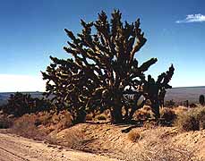
the dominant greenstuff is Mojave yucca, banana yucca (those explosions
of long sword leaves springing from a common base), buckhorn cholla
(a fancifully branched cactus, like some nightmare of a stag’s
rack), creosote bush, and squat barrel cactus, with a smattering
of prickly pear and Joshua tree, and a host of withered twiggy
clumpshrubs. Each plant has its separate presence, standing apart,
and the barrel cacti have irresistible personality. Like spiny
sea anemones left high and dry by a geologic tide, these bulbous
characters bubbleout from crevices and sheer walls, or stand like
mythic figures on the sloping ground. They make me laugh, or give
me pause. |
| We brewed up breakfast and stuffed the Owl for a flight around
the mountain, away from generator noises and the stream of commerce.
The cavers had told us that Hole in the Wall was the best campsite
with trails in the area, and warned us that a boyscout troop was
about to descend on Mitchell Caverns. We beat our wings downslope. |

Desert Rat
|

Desert Cat
|
Hole in the Wall is another kettle of cactus. A looming outcrop
of swisscheese mountains with echoing canyons and actual pockets
of shade. We hiked around the base of the bluffs, because the
canyon trail was too arduous for Peggy’s knee. We try to avoid
steep pitches, and this one was vertical enough for ringholds.
No thanks sez knee. |
| Peggy kept spotting lizards, but when I looked they had scooted.
I had the eye for birds, however, of which there are surprising
numbers in this parched place. After we had supped on tabouli
with fresh garlic and avocado, tomato and mustard-dill sauce,
under the ranger station ramada, we discovered that there was
a plant ID trail starting alongside us. So we went for another
stroll. |

Peggy's Mojave
|

Joshua Tree
|
At this season most of the leafy critters are withered virtually
nondescript, to our innocent eyes, but the cactus, woody plants,
and yuccas are distinguishable, which was fun. We got snagged
by the wait-a-minute bush, sorted out the chollas, discovered
that most of the floral variety had been invisible to us. When
we approached the 'Desert Almond: Prunus fasciculata. The almond
flavored fruit of this plant is the favorite food of the antelope
ground squirrel", a ground squirrel popped out from under it right
on cue. We followed him along the guided path. The California
State Park System does a terrific job, we thought. In fact, all
across the US state parks are the best places for camping, services,
cleanliness, etc. |
Thoroughly informed, we put our tires to the gravel again. The
parking lots were getting fuller, and we were beginning to feel
a little shriveled. Eyes smarting, sneezing at the dust and desert
incense. The thought of showers was pulling us out of the backland.
And there was a nice long circuit yet to make around the east
Mojave. We still might find a quiet pitch.
|

Desert Study
(Peggy)
|

Tarantula Country
|
Our meander circled up and around the north end of the Providence
chain, through a forest of Joshua trees, frozen in extravagant
eloquence. From a high vantage we looked across expanses of bristling
"wasteland." A lone dirt track leading west, for all the world
like an emigrant trail of the 1850s. But when I tried to focus
the camera on the image out of time, it proved elusory. Maybe
you can’t photograph the past. This desert was the last hard push
for those who crossed to California by the southern route, and
we didn’t envy them the passage. But even here in this evaporated
expanse there were cattle ranging, and waxing sleek on the fuzz
of small grasses and such, which seem to survive almost everywhere. |
| Crossing the SantaFe RR line at Kelso Junction, with its big mission
style depot and a smattering of palms in the middle of nowhere,
we navigated a wide tilted valley toward the Kelso Dunes. We had
been able to see this wrinkled puddle of white windsculpted sand
for 20 miles or more, and it looked poured out on the desert floor,
like flour spilled from a sack. But up close the signs said, “Fragile
environment: do not enter,” so we passed on. I had wanted to go
out and meet Lawrence there, and some camels, but.. |

Kelso Junction
|
We did encounter a tarantula crossing the road, and that made
our minds up. After whooping and leaping over a last hillandgully
ride, we entered the eternal highway trash zone, said goodbye
to the barrel-boys, and whooshed into the arterial rush. Highway
40. Barstow here we go.

Outcrops
|
As you travel west across Mojave the land becomes lower, dryer
and flatter. The plants don’t entirely disappear, they just space
themselves farther apart, and it begins to look like the desert
of my expectations. The shadowed mountains move back. Occasional
lava flows, looking fresh-poured, ooze downslope. Single mountains
rising from the basin speak of mythic being. And the descending
sun eased into a spreading stratus, letting our eyes cool and
our skin relax. For all our craving for solitude we are not desert
people. Even Barstow had its charm. |


